Purang County, also known as Burang County, occupies a remote yet pivotal corner of the Tibetan Plateau. Nestled between the soaring Gangdise and Himalayan mountain ranges in far‑southwestern Tibet’s Ngari Prefecture, Purang sits at an average elevation of 4,500 meters and spans more than 13,000 square kilometers. Its proximity to Nepal and India—bordering both to the south—has long made it a crossroads of trade, culture and pilgrimage. Yet beyond commerce, Purang’s real allure lies in its spiritual landscapes: the sacred Mount Kailash and the crystalline Lake Manasarovar, magnets for devout pilgrims and adventurous travelers alike.
Geographic Setting and Climate in Purang County
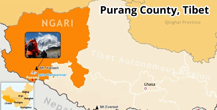
Strategic Borderland
Purang lies some 1,260 kilometers by road from Lhasa, connected by the scenic National Highways G318 and G219. To its west and southwest rise the majestic peaks of the Gangdise (Kailash) range and the southern Himalayas, while to the north stretches the vast, windswept Ngari Plateau. This natural amphitheater gives Purang the Tibetan name “Puran,” literally “one hair,” evoking the narrow, hair‑thin valley carved by the Mabja Zangbo (Peacock) River.
Plateau Microclimate
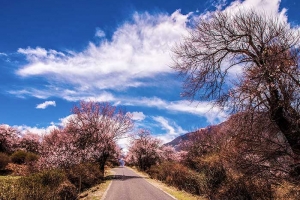
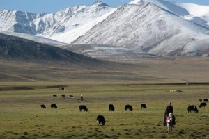
Although perched on one of the world’s highest plateaus, Purang enjoys a comparatively mild microclimate. The Mabja Zangbo River Valley dips to just 3,900 meters—over 100 meters lower than Ngari’s average—allowing warm, humid monsoon air from the Bay of Bengal to flow in through its mountain passes. Lush barley terraces, golden rapeseed blooms and stands of hardy poplar trees contrast vividly with snow‑capped peaks, creating an almost temperate oasis amid the cold high plateau.
The Lifeline in Purang County: Mabja Zangbo (Peacock) River
Source of the Ganges
Originating just east of Mount Kailash, the Mabja Zangbo is one of Tibet’s four sacred headwaters. Flowing south through Purang’s valley, it crosses into Nepal at the Niti Pass and becomes the Karnali (Ghaghara) River—an important tributary of India’s sacred Ganges. This hydrological link cements Purang’s spiritual and geographical significance for Hindu and Buddhist pilgrims following ancient pilgrimage routes.
Valley Ecology and Health Retreat
The picturesque river valley is more than scenic: its lower altitude and milder climate offer relief for travelers suffering from acute mountain sickness. Many visitors begin their pilgrimage at Manasarovar, acclimatizing here before tackling the holy circuit around Mt. Kailash. A two‑hour drive (approximately 120 km) from Kailash Base Camp brings pilgrims down into Purang’s gentler climes, passing Lake Rakshastal and Manasarovar en route.
Purang County tourist route attractions
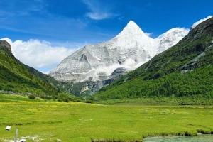
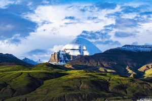
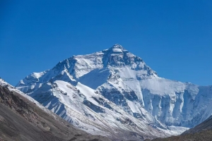
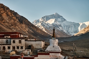
Mount Kailash (6,656 m)
Revered by Hindus, Buddhists, Jains and followers of the indigenous Bon faith, Mount Kailash is believed to be the axis mundi—the center of the universe—housing the gods themselves. Its perfect pyramidal form, perpetually draped in snow, inspires awe from every angle. Completing the 52 km kora (circumambulation) around its base is considered one of life’s greatest spiritual achievements.
Lake Manasarovar (4,588 m)
Just 20 kilometers southeast of Kailash, Manasarovar is the highest freshwater lake in the world, plunging to depths of 70 meters. Its mirror‑like surface reflects the surrounding peaks, while the Chiu Monastery on its western shore offers the best vantage for sunrise views. Pilgrims bathe in its purifying waters before their Kailash kora.
Lake Rakshastal (4,574 m)
Once joined with Manasarovar, Rakshastal—“Ghost Lake”—split from its neighbor by climatic shifts, becoming saline while Manasarovar remained fresh. Its dark, brooding waters and wind‑swept beaches lend it an otherworldly aura, embodying the yin to Manasarovar’s yang.
Border Trade and Mountain Passes in Purang County
Purang Port and Zherwa Border Crossing
For centuries, Purang Port has served as Tibet’s vibrant border trade hub with Nepal and India. From May through October—when snows abate—local caravans traverse passes such as Zherwa, Lipulekh and Tinkar to barter salt, grain and handicrafts. The most frequented is the Zherwa crossing: a simple bridge links China’s Kejia Village on the northern bank of the Mabja Zangbo with Nepal’s Hilsa Village just meters away. Seasonal airlifts from Simikot Town’s airport further facilitate pilgrim traffic to Kailash and Manasarovar.
Network of Mountain Routes
Over twenty high‑altitude tracks fan out from Purang, threading through narrow defiles and over 5,000‑meter passes. Apart from pilgrimage, these ancient routes underscore Purang’s historic role as a cultural conduit between the Tibetan plateau and the Indian subcontinent.
Transportation and Accessibility in Purang County
A purpose‑built highway now links Purang directly with Shigatse to the east (and thence to Lhasa, some 1,200 km away) and with Shiquanhe (Ali Prefecture seat) to the north. Regular shuttle buses ply the Shiquanhe–Purang route in six to eight hours, while independent travelers may hire licensed tourist vehicles. International visitors require chartered transport to navigate border formalities and restricted roads.
Heritage Villages and Monasteries in Purang County
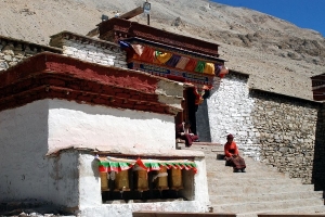
Kejia Village and Monastery
Dating back over a millennium, Kejia Village clusters around its 12th‑century Kejia Monastery, built to house a statue of Manjushri Bodhisattva blessed by the renowned translator Rinchen Sangpo. This thousand‑year‑old community preserves traditional Tibetan opera and ancient rites, offering an intimate glimpse into pastoral plateau life.
Xianbolin Monastery
Perched above the Mabja Zangbo and founded under the Fifth Dalai Lama in the early 1600s, Xianbolin (Shetrul) Monastery was the first major Gelugpa institution in Ngari. Its hilltop vantage affords sweeping views of the river valley and distant glaciers, while its walls hold centuries of mural art and sacred relics.
Best Time to Visit and Sample Itinerary in Purang County
Optimal Season: June to August
Summer brings full barley fields, blooming rhododendrons and clear skies—ideal for photography and pilgrimage alike. By contrast, winter snows close the passes and halt border trade.
Suggested 7‑Day Route
- Day 1–2: Arrive in Purang; acclimatize in the Mabja Zangbo Valley
- Day 3: Lake Manasarovar circuit and Chiu Monastery visit
- Day 4: Sunrise at Mount Kailash; begin kora
- Day 5: Complete Kailash circumambulation; rest in Dirapuk Monastery
- Day 6: Explore Lake Rakshastal and Mt. Namonanyi viewpoints
- Day 7: Return via Kejia Village and Xianbolin Monastery; depart Purang
Purang County offers an intoxicating blend of raw natural beauty, profound spirituality and living cultural heritage. From the rainbow‑hued fields of the Mabja Zangbo Valley to the silent sanctity of Mount Kailash’s slopes, every step through Purang reveals a new facet of Tibet’s mystique. For travelers seeking not only a breathtaking journey but a transformative pilgrimage, Purang is the gateway to the heart of the roof of the world. Whether you come to trade, trek or transcend, the magic of Purang County awaits your discovery.